30 year reunion
Re: 30 year reunion
![]() by John Burroughs » Sat Aug 15, 2009 10:37 pm
by John Burroughs » Sat Aug 15, 2009 10:37 pm
- John Burroughs
- Posts: 964
- Joined: Thu Jan 17, 2008 9:16 pm
Re: 30 year reunion
![]() by Andy » Sat Aug 15, 2009 10:54 pm
by Andy » Sat Aug 15, 2009 10:54 pm
She didn't put those four words into bold type in her book, but i did it, because that is what has confused me. I hadn't red it closely enough, and that is what had confused me. Not that difficult for me i'm afraid
- Andy
- Posts: 280
- Joined: Sun Sep 03, 2006 8:14 am
- Location: Ipswich
Re: 30 year reunion
![]() by puddlepirate » Sat Aug 15, 2009 11:01 pm
by puddlepirate » Sat Aug 15, 2009 11:01 pm
Re routes into the forest. I have no idea if this route was there in 1980 but dead opposite Folly House is a wide ride that goes all the way up, almost to the northwest corner of the farmer's field. It's wide enough to drive a couple of tanks in line abreast along it and it's where the concrete manhole covers are sited about 150 yards apart - which follow the ride for most of its length.
I've got some phots of it but can't work out how to post images!
- puddlepirate
- Posts: 637
- Joined: Mon Nov 26, 2007 11:47 am
- Location: UK
Re: 30 year reunion
![]() by AdrianF » Sat Aug 15, 2009 11:04 pm
by AdrianF » Sat Aug 15, 2009 11:04 pm
John Burroughs wrote:Do you remember when he described the route and would they be able to get the lighalls and equipment in the same area we were in or was it where Halt said he was? And can you show on the map also where Halt has said he was when he was first investigating the incident?
I've gone from Larry's account in LAEG. I will look back over one of his earlier interviews tonight to see if he mentioned this there.
Ian R gives a good account on his site of how Col. Halt went into the forest. I looked at Ian's map today and it does tally with what I'm suggesting:
http://www.ianridpath.com/ufo/rendlesham2d.htm
Lighalls could easily have been taken down that route, and the landing site from there (the south side) is not that far into the forest
Not being a military guy myself I can't really suggest what would be proper procedure, but from a common sense point of view, this would be the logical way of getting this kind of machinery into this position.
- AdrianF
- Posts: 330
- Joined: Fri Jan 18, 2008 2:57 pm
Re: 30 year reunion
![]() by Andy » Sat Aug 15, 2009 11:07 pm
by Andy » Sat Aug 15, 2009 11:07 pm
puddlepirate wrote:Andy.. thanks for that.
Re routes into the forest. I have no idea if this route was there in 1980 but dead opposite Folly House is a wide ride that goes all the way up, almost to the northwest corner of the farmer's field. It's wide enough to drive a couple of tanks in line abreast along it and it's where the concrete manhole covers are sited about 150 yards apart - which follow the ride for most of its length.
I've got some phots of it but can't work out how to post images!
Not sure PP. Adrian would probably be able to answer that as he has the maps. I do remember walking down route 10 though with BB and pointing out to her the site that Bruni shows on the map in her book which she claimed Vince Thurkettle showed her. However, she said to me 'Nothing happened the other side of route 10.'
- Andy
- Posts: 280
- Joined: Sun Sep 03, 2006 8:14 am
- Location: Ipswich
Re: 30 year reunion
![]() by Andy » Sat Aug 15, 2009 11:13 pm
by Andy » Sat Aug 15, 2009 11:13 pm
AdrianF wrote:John Burroughs wrote:Do you remember when he described the route and would they be able to get the lighalls and equipment in the same area we were in or was it where Halt said he was? And can you show on the map also where Halt has said he was when he was first investigating the incident?
I've gone from Larry's account in LAEG. I will look back over one of his earlier interviews tonight to see if he mentioned this there.
Ian R gives a good account on his site of how Col. Halt went into the forest. I looked at Ian's map today and it does tally with what I'm suggesting:
http://www.ianridpath.com/ufo/rendlesham2d.htmLighalls could easily have been taken down that route, and the landing site from there (the south side) is not that far into the forest
Not being a military guy myself I can't really suggest what would be proper procedure, but from a common sense point of view, this would be the logical way of getting this kind of machinery into this position.
Mr Ridpath certainly do seem to be in the same area too, and describes, that until now elusive track that Tex showed me, and John also mentions in his statement. I think what has confused us for a long time is that we have assumed John et al went down what was route 12. They didn't, but i really am convinced Larry Warren did. Things so seem to be slotting more into place now.
- Andy
- Posts: 280
- Joined: Sun Sep 03, 2006 8:14 am
- Location: Ipswich
Re: 30 year reunion
![]() by Andy » Sat Aug 15, 2009 11:21 pm
by Andy » Sat Aug 15, 2009 11:21 pm
- Andy
- Posts: 280
- Joined: Sun Sep 03, 2006 8:14 am
- Location: Ipswich
Re: 30 year reunion
![]() by AdrianF » Sat Aug 15, 2009 11:35 pm
by AdrianF » Sat Aug 15, 2009 11:35 pm
I think what has confused us for a long time is that we have assumed John et al went down what was route 12. They didn't, but i really am convinced Larry Warren did
I always assumed this too, or that there were different sites being investigated, but now I'm convinced that the old road was the route in on night one and on subsequent nights, the 2 main logging roads were probably used.
- AdrianF
- Posts: 330
- Joined: Fri Jan 18, 2008 2:57 pm
Re: 30 year reunion
![]() by Andy » Sat Aug 15, 2009 11:46 pm
by Andy » Sat Aug 15, 2009 11:46 pm
In Bruni's book:
'Penniston looked down the perimeter road and could see what appeared to be different coloured lights.....'
Going on the previous assumption of what was route 12 and some distance down the road on the right, i had always found this confusing, as there is no way he would have seen those lights from East gate to route 12? However, the elusive logging track/path, yes most definitely he would be able to.
'The patrol then turned right (at the end of the East gate road) and, taking a SHARP LEFT turn (if they had gone to route 12 it would not have been a sharp left by any stretch of the imagination, but the path we are talking about WOULD be a sharp left) drove up the adjacent logging road into the forest, but due to the rocky terrain they had to abandon the vehicle and proceed on foot.'
I'm just so glad you made your initial posting Adrian, because as said i had come to the same and similar conclusions a while back, but it is so good to hear someone else saying the same and have come to the same conclusions. It makes me feel all that more certain that what i have been thinking, and you obviously are too, is in fact correct.
- Andy
- Posts: 280
- Joined: Sun Sep 03, 2006 8:14 am
- Location: Ipswich
Re: 30 year reunion
![]() by John Burroughs » Sat Aug 15, 2009 11:47 pm
by John Burroughs » Sat Aug 15, 2009 11:47 pm
Can you post on the map where Halt saw the red glowing object that broke into different lights. Also where he had the blue light beame down the light!
- John Burroughs
- Posts: 964
- Joined: Thu Jan 17, 2008 9:16 pm
Re: 30 year reunion
![]() by Andy » Sun Aug 16, 2009 12:17 am
by Andy » Sun Aug 16, 2009 12:17 am
'They parked by the East gate of the base and Chuck (Halt's son) led the team along a dark track that paralled the main dirt road (route 12?) into the forest. With schoolboy enthusiasm he explained that this was the way the men from the gate had come...... Chuck said he had often been to the site since his father had first showed it him, and he could remember landmarks well, despite the dark. He pointed these out as he SURGED ON THROUGH THE TALL GRASS.' ?? Could this have been the small open field John mentions?? and you have also mentioned in your post and on the map
There is another mention of the track if i recall somewhere else in the book involving Halt himself, as said it is late though and you have kept me up far too late with your inspiration. And if i'm late for work tomorrow, God help you!
Catch up tomorrow.
- Andy
- Posts: 280
- Joined: Sun Sep 03, 2006 8:14 am
- Location: Ipswich
Re: 30 year reunion
![]() by Andy » Sun Aug 16, 2009 1:41 am
by Andy » Sun Aug 16, 2009 1:41 am
I wont take my three greyhounds because the last time i took them deep within during my investigations, they came across an adder, and sight hounds are notoriously quick, but luckily i grabbed them in time, and it slithered away. However, having said that, there is a small part of Rendlesham (on route 12 up near the farmer's field) i want to show you, (and just beyond LW's staging post that he describes), and my dogs have regularly acted really strangely there, and compasses will go hay-wire, and mobile phones react. You have to witness it to believe it, but various others have.
What do you think? Sounds great fun to me, and we could also investigate capel green 'Lion's corner' etc.
If interested, as said PM me. If you live out of area, no problem, i have a spare room you are welcome to stay in whilst visiting the area.
- Andy
- Posts: 280
- Joined: Sun Sep 03, 2006 8:14 am
- Location: Ipswich
Re: 30 year reunion
![]() by AdrianF » Sun Aug 16, 2009 8:50 am
by AdrianF » Sun Aug 16, 2009 8:50 am
Can you post on the map where Halt saw the red glowing object that broke into different lights. Also where he had the blue light beame down the light!
John, I've always assumed that this was on the other side of the farmers field, going by the tape recording. I will add to the map over time to include the second night, but as I said earlier I am still unsure of the route that you all took beyond the farmhouse on both nights. As this hasn't really changed over the years, at least you stand some chance of recalling your steps when you visit.
'The patrol then turned right (at the end of the East gate road) and, taking a SHARP LEFT turn (if they had gone to route 12 it would not have been a sharp left by any stretch of the imagination, but the path we are talking about WOULD be a sharp left) drove up the adjacent logging road into the forest, but due to the rocky terrain they had to abandon the vehicle and proceed on foot.'
Andy, thanks, the more I think about this the more it makes perfect sense. I'll be going down there again later this week, so if you want to meet up and go over this then great, will pm you
- AdrianF
- Posts: 330
- Joined: Fri Jan 18, 2008 2:57 pm
Re: 30 year reunion
![]() by puddlepirate » Sun Aug 16, 2009 10:54 am
by puddlepirate » Sun Aug 16, 2009 10:54 am
Looking towards the runway: http://www.flickr.com/photos/31080006@N07/3826123066
Looking towards the farmer's field: http://www.flickr.com/photos/31080006@N07/3826122638
and a couple of close ups of the manhole covers:http://www.flickr.com/photos/31080006@N07/3825323009
http://www.flickr.com/photos/31080006@N07/3825322787
- puddlepirate
- Posts: 637
- Joined: Mon Nov 26, 2007 11:47 am
- Location: UK
Re: 30 year reunion
![]() by Andy » Sun Aug 16, 2009 11:19 am
by Andy » Sun Aug 16, 2009 11:19 am
- Andy
- Posts: 280
- Joined: Sun Sep 03, 2006 8:14 am
- Location: Ipswich
Re: 30 year reunion
![]() by puddlepirate » Sun Aug 16, 2009 11:59 am
by puddlepirate » Sun Aug 16, 2009 11:59 am
I've got no idea.. Obs was quite adamant that they were only 8ft wide...don't know if he posted that info or PM'd it. I thought it odd but Obs is local to the area and knows it well... grew up there apparently. I'm not familiar with either the area or the logging roads so can't really comment as to how wide the logging roads were in 1980 or what type of logging equipment was used. Obs suggested they used chainsaws to fell the trees and trailers hauled by small tractors to move the trunks around but as I say, I've absolutely no idea so I bow to the superior knowledge of those like yourself who know the area well.
I suppose as far as the RFI goes it would depend on where they wanted the kit. They'd take the vehicles down the route that was easiest and nearest to wherever the kit needed to be. After all they would need to turn the vehicles and lightalls around to get them out. Once the location of the incident had been confirmed by foot patrols, they could take the vehicles down whatever route suited them best. So I suppose in that context just because the guys on foot took route 12 it doesn't mean the vehicles did.
- puddlepirate
- Posts: 637
- Joined: Mon Nov 26, 2007 11:47 am
- Location: UK
Re: 30 year reunion
![]() by puddlepirate » Sun Aug 16, 2009 1:16 pm
by puddlepirate » Sun Aug 16, 2009 1:16 pm
DEFE 24/1948
Scope and content UFO reports of sighting: Rendlesham Forest, December 1981
Covering dates 1992 Jan 01 - 2002 Dec 31
Availability Closed Or Retained Document, Open Description, Closed For 30 years
Former reference (Department) D/Sec(AS) 12/2/1 Part A
Held by The National Archives, Kew
The above also applies to this document:
DEFE 24/1948/1 which is the same as the above but with redactions
Notice the date.. 1981 NOT 1980
Just in case these are not being released, I have requested a review.
- puddlepirate
- Posts: 637
- Joined: Mon Nov 26, 2007 11:47 am
- Location: UK
Re: 30 year reunion
![]() by Andy » Sun Aug 16, 2009 8:53 pm
by Andy » Sun Aug 16, 2009 8:53 pm
You can see the logging path in question.
What had also confused me was the drawings/maps giving directions to the landing site, made my Penniston. But they too now make sense. Until recently i had always thought that once they came to the end of East gate road, took a right, then turned into the forest, was too soon and route 12 would not be that close on the scale of things. They most definitely went down that track. No doubt about it. Penniston also said they took a true East direction whilst on that track. All we need to do now is try (probably will be impossible) is as said follow it and see where it leads us to?
Also in Sky crash, the photo i mention in a previous post about the Japanese crew on route 12? Underneath the photo it gives the description 'Japanese TV producer Jim Yaoi, pictured with his camera crew in January 1984 during the making of their documentary on the sky crash. They are at the 'staging post' described by Art Wallace (LW). Trucks and jeeps were left here and the security officers approached the site on foot, through the trees to the left of the picture.'
I can't find that bit about Halt Senior showing BB the site? I'm sure i red it somewhere. The only other book i have is UFO crash landing, so perhaps it was in there? I shall have to have a look through that.
- Andy
- Posts: 280
- Joined: Sun Sep 03, 2006 8:14 am
- Location: Ipswich
Re: 30 year reunion
![]() by AdrianF » Sun Aug 16, 2009 9:49 pm
by AdrianF » Sun Aug 16, 2009 9:49 pm
Also in Sky crash, the photo i mention in a previous post about the Japanese crew on route 12? Underneath the photo it gives the description 'Japanese TV producer Jim Yaoi, pictured with his camera crew in January 1984 during the making of their documentary on the sky crash. They are at the 'staging post' described by Art Wallace (LW). Trucks and jeeps were left here and the security officers approached the site on foot, through the trees to the left of the picture.'
I remember this photo, but don't remember the quote, which does support the idea that the lightalls were put into this area via what was track 12. Look forward to maybe meeting up this week..
PP, thanks for the nod on the MOD files
- AdrianF
- Posts: 330
- Joined: Fri Jan 18, 2008 2:57 pm
Re: Orienteering
![]() by Andy » Sun Aug 16, 2009 9:51 pm
by Andy » Sun Aug 16, 2009 9:51 pm
AdrianF wrote:I walked over the area again yesterday, this time only reading the three original statements and a forest planting map as a guide. I now think that the FC were pretty close with their calculation as was Brenda Butler and I think that Jim Penniston should be forgiven for identifying a second site and with good reason ( apologies to Jim if it seems I'm putting words in his mouth ). I've come to this conclusion after being given a planting map by the FC, which shows how the designated areas were planted by year and tree type.
My aim is to produce a reasonably accurate animatic of the events from this planting map, using the original statements as a guide. All later comments I'm excluding, as the forest appears to have changed so much during the 80's that it would require a huge effort to recall exact locations. Having said that, most of the later statements now seem to make perfect sense including Larry Warrens route into the forest and the area where the lightalls were probably positioned on the 3rd night.
I've created a very rough overlay map, which I hope should give some idea of what I think might have happened here and why there is still so much confusion. IMO this stands the best chance of being resolved with the use of photographs or film footage from the time, as this will confirm how this particular part of the forest looked back then.
The area ringed in white is the approximate area now known as the landing site, the one investigated by Verano and Gulyas and subsequently Halts team. It potentially could have been a little further east, but is more or less what most people agree on being the landing site area.
The X marked A seems to be the area JP sketched in the statements. It should have looked then much like the X marked B does now, hence the confusion.
The 1st area ringed in green which was replanted in 75 is very likely the area referred to as the first clearing or field crossed.
The 2nd area ringed in green containing the landing site, was most likely the forest that was passed through before entering the second field.
The route taken beyond the farm house is still a little confusing, but I would think could be solved as this has changed very little to my knowledge.
Going over the statements at the site, they are actually quite accurate accounts of the ground covered, particularly John's statement.
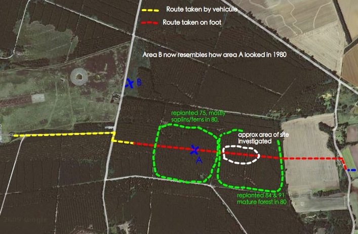
On your aerial map, you very clearly show the now non-existent path. Going on a bit further down the road from where that enters the forest you come to what was route 12. Follow that along and you will see it suddenly forks in two. That is where LW's staging post was and where we believe the lightalls were stationed. If you look over to the left of this, you will see the close proximity of the landing site, and how the lightalls could have quite easily illuminated the area. At that forked staging post site, from there onwards and continuing on the route 12 path down to the farmer's field is the area i told you about with dogs acting strangely, compasses, and mobile phones mal-functioning etc. I've always wondered if this is the area Andrew Sheepshanks told GB about, and 'had found very spooky.... (and) As a youngster he would often walk his dogs through the forest, but it seems they would never go anywhere near this particular spot.' ??
Strange that even today odd phenomenon still happen as described above, and that it is so close to the landing sites also, both JB & JP's and LW's?
- Andy
- Posts: 280
- Joined: Sun Sep 03, 2006 8:14 am
- Location: Ipswich
Return to The Rendlesham forest incident
Who is online
Users browsing this forum: No registered users and 2 guests