Ian was right
Re: Ian was right
![]() by John Burroughs » Mon Nov 08, 2010 9:00 pm
by John Burroughs » Mon Nov 08, 2010 9:00 pm
- John Burroughs
- Posts: 964
- Joined: Thu Jan 17, 2008 9:16 pm
Re: Ian was right
![]() by stephan » Mon Nov 08, 2010 9:18 pm
by stephan » Mon Nov 08, 2010 9:18 pm
John Burroughs wrote:And when do lighthouses or planets beam down lights to the ground and move around like they did.
I don't know if you ever heard of so-called light-pillars. It's just an suggestion.
http://en.wikipedia.org/wiki/Light_pillar
more pics here: http://www.google.de/images?hl=en&sourc ... =&gs_rfai=
-
stephan - Posts: 230
- Joined: Tue Jun 15, 2010 9:10 pm
- Location: Germany
Re: Ian was right
![]() by stephan » Mon Nov 08, 2010 9:24 pm
by stephan » Mon Nov 08, 2010 9:24 pm
Wiki wrote:A light pillar is a visual phenomenon created by the reflection of light from ice crystals with near horizontal parallel planar surfaces. The light can come from the sun (usually at or low to the horizon) in which case the phenomenon is called a sun pillar or solar pillar. It can also come from the moon or from terrestrial sources such as streetlights.
... such as street-lights or ... the lighthouse ? I don't know either, haven't seen any of 'em so far
-
stephan - Posts: 230
- Joined: Tue Jun 15, 2010 9:10 pm
- Location: Germany
Re: Ian was right
![]() by puddlepirate » Mon Nov 08, 2010 9:40 pm
by puddlepirate » Mon Nov 08, 2010 9:40 pm
- puddlepirate
- Posts: 637
- Joined: Mon Nov 26, 2007 11:47 am
- Location: UK
Re: Ian was right
![]() by AdrianF » Mon Nov 08, 2010 10:52 pm
by AdrianF » Mon Nov 08, 2010 10:52 pm
damn, you people make me wish to go to Capel Green and film that damn lighthouse for myself. But that would be more than just a short trip to Cologne ... I've read somewhere that it is going to be turned off in 2011 once and for all but I dunno if it's true.
When I visited the Ness in the summer, the warden told me that the lighthouse could be switched off by the end of the year, though it could also keep running for a year or 2. I don't think it's got long though.
I don't know about sun pillars but I've photographed a sun dog over Orford from the sea wall.
John, are you fixed for the 28th then? I will probably try and get there if that is the case.
- AdrianF
- Posts: 330
- Joined: Fri Jan 18, 2008 2:57 pm
Re: Ian was right
![]() by Admin » Mon Nov 08, 2010 10:55 pm
by Admin » Mon Nov 08, 2010 10:55 pm
John, are you fixed for the 28th then? I will probably try and get there if that is the case.
I would like some more information too, John. December's approaching fast!
- Admin
- Administrator
- Posts: 172
- Joined: Sun Jan 30, 2011 8:47 pm
- Location: London, England
Re: Ian was right
![]() by puddlepirate » Mon Nov 08, 2010 11:52 pm
by puddlepirate » Mon Nov 08, 2010 11:52 pm
At about 1:17 (the last clip in the series) there are a couple of reddish yellow coloured lights just right of centre towards the bottom of the frame. They must be in the field somewhere - several yards forward of where you were standing...any idea what they are?
- puddlepirate
- Posts: 637
- Joined: Mon Nov 26, 2007 11:47 am
- Location: UK
Re: Ian was right
![]() by puddlepirate » Tue Nov 09, 2010 12:21 am
by puddlepirate » Tue Nov 09, 2010 12:21 am
The last vid clip of the set, the one taken 10 to 15 yards north of the picnic bench, was taken directly in front of the farmhouse (by carefully studying the lights I mentioned previously it can be seen they are lights in the windows of the farmhouse). This is in the same location as Ian R took his photo of the lighthouse from, yet in your vid the light is high and to the left of the house, where the horizon is higher than to the right of the house - while in Ian R's pic taken from the same location (and published in this thread) it is some distance away to the right of the farmhouse. Considering how far away the light is, that is a substantial difference. Any idea why that should be?
- puddlepirate
- Posts: 637
- Joined: Mon Nov 26, 2007 11:47 am
- Location: UK
Re: Ian was right
![]() by AdrianF » Tue Nov 09, 2010 9:14 am
by AdrianF » Tue Nov 09, 2010 9:14 am
The last vid clip of the set, the one taken 10 to 15 yards north of the picnic bench, was taken directly in front of the farmhouse (by carefully studying the lights I mentioned previously it can be seen they are lights in the windows of the farmhouse). This is in the same location as Ian R took his photo of the lighthouse from, yet in your vid the light is high and to the left of the house, where the horizon is higher than to the right of the house - while in Ian R's pic taken from the same location (and published in this thread) it is some distance away to the right of the farmhouse. Considering how far away the light is, that is a substantial difference. Any idea why that should be?
Good point. My guess is, that as I was filming from the very limit of where the light is visible ( on the viewers extreme left ), north of the bench and I was zoomed in, it appears this way. I don't know exactly where Ian took his picture, but if he was in line with the bench and zoomed in, then it would appear off to the right. To be honest I don't really know.
I visited the site with Ian this summer and he paced out the visible corridor in the dark. I think from memory this was actually around 60 yards ( as opposed to the 100 yards I wrote on my page ). So around 20 yards North of the bench and around 40 to the south.
- AdrianF
- Posts: 330
- Joined: Fri Jan 18, 2008 2:57 pm
Re: Ian was right
![]() by Frank » Tue Nov 09, 2010 11:23 am
by Frank » Tue Nov 09, 2010 11:23 am
Multiple military witnesses that hallucinate and observe fast moving objects in a small lighthouse light, stars and planets; mathematical rabbits that love radioactive rock formations; and now light pillars enter the scene ..
But the data tell a very clear and different story:
The beams that Halt observed were momentary (switched on and off), were emitted by an object that moved across the sky at high speed, and were all emitted by only one of the objects they observed; the same object that on one occasion approached the men at high speed and sent down a beam at their feet.
Tape:
LT COLONEL HALT: 3.15: Now we've got an object about ten degrees directly south...
SGT NEVILLES: There's one to the left.
LT COLONEL HALT: 10 degrees off the horizon, and the ones to the north are moving, one's moving away from us.
SGT NEVILLES: It's moving out fast.
LT COLONEL HALT: They're moving out fast.
MASTER SGT BALL: There's one on the right heading away too.
LT COLONEL HALT: Yeah, they're both heading north. Hey, here he comes from the south; he's coming in toward us now.
MASTER SERGEANT BALL: Shit.
LT COLONEL HALT: Now we’re observing what appears to be a beam coming down to the ground.
[Excited shouting in the background]
MASTER SGT BALL: Look at the colors... shit
LT COLONEL HALT: This is unreal.
Memo (=watered down version):
The object to the south was visible for two or three hours and beamed down a stream of light from time to time.
Earthfiles interview:
Then we noticed other objects to the south and one of them approached us at very high speed. My guess is that it was 3,000 to 4,000 feet, maybe lower. I can’t tell for sure.
(…)
The object stopped overhead and sent down a beam. (…) The light was a very bright, white light – probably 15 to 20 inches in diameter, something of that size – when it hit the ground. It was right in front of us, less than ten or fifteen feet away.
(…) And we just stood there for maybe five to ten, maybe fifteen seconds, and then it was gone. I mean, it disappeared as suddenly as it appeared.
A light pillar is an optical illusion that needs a light source.
A low altitude light source cannot create the illusion of an object overhead. Either the light pillar is way in front of you or it is above and seems to come from nowhere. On top of that, a low altitude light source needs to be very close by to create the illusion of a light beam coming down from above and the light pillar will always point away from the observer.
What about a high altitude light source? If you assume there were only stars and planets in the air, there were no high altitude light sources of sufficient strength to create the light beam effect (stars and planets merely create a small halo-alike effect). Moreover, a star or planet certainly does not create the illusion of a beam being switched off like you throw a light switch.
On top of this, if the atmospheric conditions were good all light sources of sufficient strength will create the light pillar illusion. Not just one.
- Frank
- Posts: 325
- Joined: Sun Apr 11, 2010 1:04 pm
Re: Ian was right
![]() by stephan » Tue Nov 09, 2010 2:51 pm
by stephan » Tue Nov 09, 2010 2:51 pm
now we're observing what appears to be a beam coming down to the ground ...
he neither mentions that it is coming down to their feet nor does he mention its thickness or appearance. I would have thought that this would have been mentioned as that would be quite spectacular.
and then he says:
3:30 or 03:30, and the objects are still in the sky although the one to the south looks like it's losing a little bit of altitude. We're turning around and heading back toward the base. ... the object to the s, the object to the south is still beaming down lights to the ground. ... 04:00 hours, one object is still hovering over Woodbridge base at about five to ten degrees off the horizon, still moving erratic and similar lights and beaming down as earlier.
so it could also be two (instead of one) objects beaming down light, one to the south and one to the west as Woodbridge base is to the west and he says ''it's still hovering'' there (i.e. it had been there before). I don't tie myself down to light pillars being responsible for that, as I said this is just an suggestion! There could also be other explanations for that. For example as he's the only one who says that there are beams coming down it could be possible that he said that while looking through the starscope and there may have been some ''beam'' like reflections in it as well as ''erratic'' movements (due to vibrations). But I don't know, the tape won't tell us if he was observing the objects with or without the starscope when he mentioned the beams.
But let's also have a look at the positions of the stars at that time (he mentions the time, so we can check that). For this purpose you can use Stellarium. Ian has done so (without Stellarium) and mentioned the very bright ones Sirius, Vega and Deneb. Especially the first two stand out when you look at the night sky.
Halt says:
3:05, at about, er, ten degrees, horizon, directly north, we've got two strange objects, er, half-moon in shape, dancing about with colored lights on'em. At, er, guess to be about five or ten miles out, maybe less. The half moons have now turned into full circles as though there was a dilept ... eclipse or something there for a minute or two. ... 03:15, now we've got an object about ten degrees directly south, ten degrees off the horizon
so which stars do we have at 3:05 am approx. ten degrees above horizon and directly north, it's Deneb and Vega:
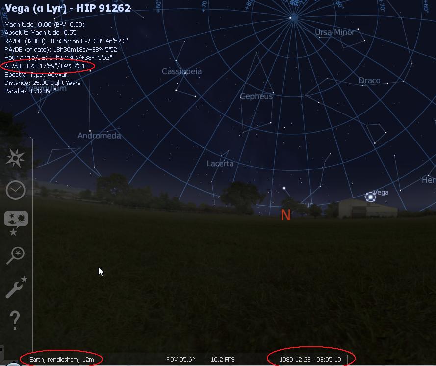
he says they were half-moon in shape, could be an optical effect while looking through the starscope. The dancing with colors could be twinkling (scintillation/ refraction effects) especially low above the horizon! And amazingly they stay in the North:
H: and the ones to the north are moving, one's moving away from us
V: moving ... all
N: moving out fast
V: this one on the right it's heading away, too
H: they are both heading north
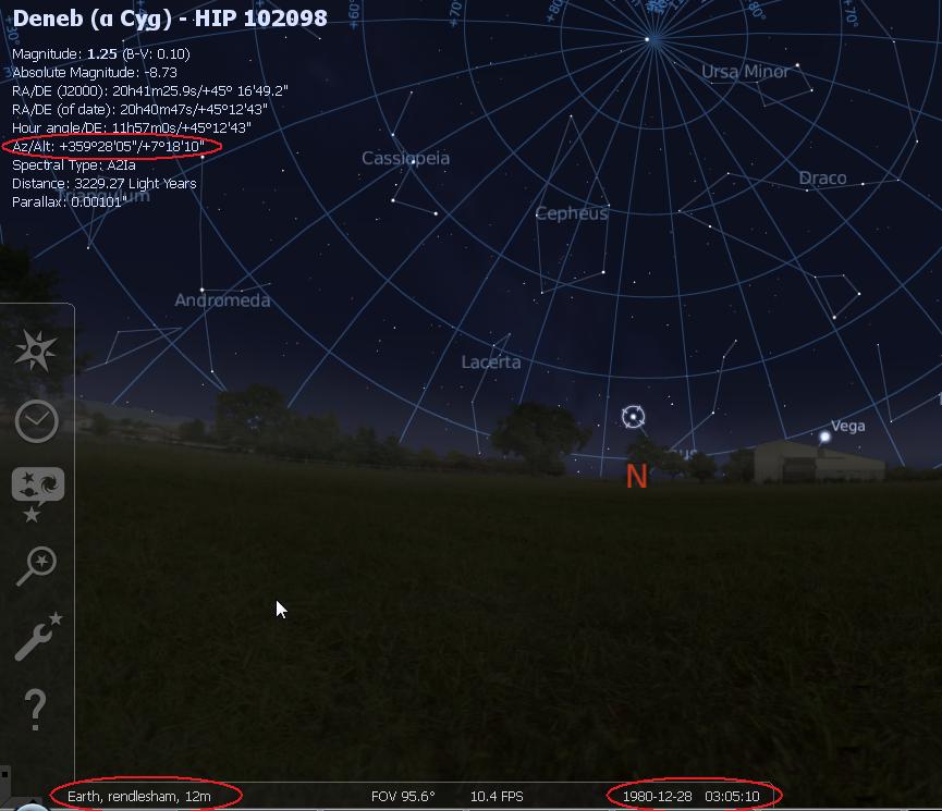
the other object is about ten degrees directly south. Stellarium shows in this position (with only a relatively small deviation of 30° from the South) the very bright star Sirius:
and again, this ''object'' stays in the South, although loosing a bit of altitude - as you would suspect if you consider that Sirius was going down:
H: this is unreal ... 3:30 or 03:30, and the objects are still in the sky although the one to the south looks like it's losing a little bit of altitude. We're turning around and heading back toward the base. ... the object to the s, the object to the south is still beaming down lights to the ground.
no, I don't ignore what wouldn't fit naked eye observations of stars, i.e. the erratic/ fast movements as well as the beams of light. But again, does anybody know for sure that when they said these things that they were not looking through the starscope ?
btw Ian, the object over Woodbridge base in the west may have been either Aldebaran or Rigel (latter is about 25° off the west).
04:00 hours, one object is still hovering over Woodbridge base at about five to ten degrees off the horizon
Stellarium:
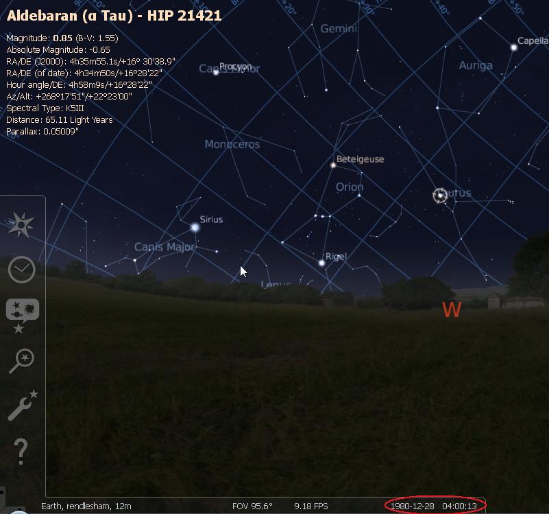
although Aldebaran's altitude wasn't 5 to 10 degrees like Halt says it could be that when they were heading back to the base he saw it 5 to 10 degrees above the forest (which he then would have taken as the horizon). Or it was Rigel, which indeed was between 5 to 10 degrees above horizon, 8°22' to be precise. Both stars have a relatively high magnitude ... especially when seen through a starscope
-
stephan - Posts: 230
- Joined: Tue Jun 15, 2010 9:10 pm
- Location: Germany
Re: Ian was right
![]() by puddlepirate » Tue Nov 09, 2010 3:15 pm
by puddlepirate » Tue Nov 09, 2010 3:15 pm
Sources for the following:
- Ordnance Survey map Explorer Series 212 (Woodbridge & Saxmundham)
MacMillan & Silk Cut Nautical Almanac 1991 (the oldest I have that shows the Shipwash light)*
*For those of you not familiar with nautical almanacs, do not be deceived by the title. MacMillan’s is a standard reference work widely used by mariners and particularly so in the days before GPS. It is not some cheap give-away from a tabloid newspaper or tobacco company. The other widely used almanac is Reeds. Both almanacs and the Explorer series OS maps are usually available in UK public libraries.
Note: All bearings are True (T). Magnetic variation in 1980 was approx 3 deg W (negative). This means that a bearing of 110 Magnetic equals 107 (T). Heights are given in metres (m) above sea level. On OS maps there is a very slight variation between grid north and true north but as this is such a slight variation, the usual advice is to ignore it.
1. From the OS map it can be seen that when standing directly in front of the farmhouse in the location from where the photograph and the video clip were taken, the observer is facing due east i.e 090 (T) on ground at 23m. Also from the OS map it can be seen that from this corner of the farmer’s field the lighthouse also bears due east. Therefore, from this position the lighthouse and thus any light it emits, should appear directly above the farmhouse - but there is the problem of the light being only 28m above sea level and 5.5 miles away, behind 19m of high ground to the north of Gedgrave Hall. Gedgrave Hall lies approximately halfway between the field and the light. As Stephan has proven with his photograph of the torch and the bin, the further away an object is, the smaller it becomes, with the view of the larger object being blocked by a much smaller object closer to the observer. Consequently, there are two questions:
a. Why does Ian R’s photo show the lighthouse approx 20 deg off to the south and Adrian F’s video clip show the light 20 deg off to the north when both were taken from virtually the same spot looking directly at the farmhouse?
b. How can a 28m light be seen by an observer standing 5.5 miles away on ground at 23m with 19m of high ground in direct line of sight between the two. The angle of view over that distance would reduce the lighthouse to a far off speck, easily blocked by the 19m high ground north of Gedgrave Hall.
2. Halt mentioned seeing lights on a bearing of 110. It is not known if he used a compass or relied on his knowledge of the area (or as an airman, perhaps the stars) to determine that he was heading due east, then made a dead reckoning estimation of the bearing of what he was seeing. However, in either case from the part of the farmer’s field from where the lighthouse is allegedly visible (23m), a bearing of 110 follows the southernmost tree line of Oak Wood (10m), out across the low ground at Butleyferry Farm (0 – 2m) that lies between the high ground of Burrow Hill (15m) to the north and the high ground at Boyton (15m) to the south, then across Chantry Marshes (0m) and the Butley River to pass south of Gedgrave Broom (19m) out over Havergate Island, approx 2.75 miles south of the Orfordness light. Therefore he could not have seen the lighthouse. However, in 1980 and on the same bearing the Shipwash lightship was anchored off the coast in pos’n 52 02 03N 01 42 05E. If and I stress if, Halt was in the vicinity of the south western corner of the farmer’s field, somewhere near the edge of Oak Wood and looking along a bearing of 110 he could well have seen the Shipwash light. The Shipwash light gave a group of three white flashes every 20 seconds.
3. What then of the light filmed by Adrian F that appears approx 20 deg to the north of the farmhouse. Given the farmhouse bears 090 then 20 deg to the north is 070. On a bearing of 070 are the very tall aerial masts of the BBC’s World Service transmitters. There are eleven of these grouped together at the old Cobra Mist site to the north of Orford Ness. The group of masts lies witin an arc between 070 and 075. Each is much taller than the Orfordness light and has a red light affixed to the top as a warning to aircraft. Despite being almost six miles away, because of their height the nearest mast should be visible above the tree line – and the nearest lies on a bearing of almost exactly 070.
These masts might have accounted for some of the lights Halt reported seeing towards the north, particularly if they were showing through the very tops of the distant treeline to give the impression of movement and / or flashing. Even if the lighthouse could be seen from the edge of the field, it would have disappeared from view almost immediately he started down the incline of the farmer’s field, so if he did see the lighthouse it could only been for a few brief moments - and only then if he was in exactly the right place, looking in the right direction at exactly the time of tiny flash of light.
NB This is not intended to be an explanation of ALL that Halt saw but it might explain SOME of what he saw. Nor is it intended to resolve what JB and JP saw on night one - it doesn't come close to that. Also, I fully expect this to be dismissed as utter b/s, farbrication, imagination, far fetch nonsense, effects of telephoto lenses etc etc but before that I strongly recommend the critics take a look at the vid clips and images already posted by Ian R and Adrian F plus check OS 212 and MacMillan to verify all of the above for themselves
- puddlepirate
- Posts: 637
- Joined: Mon Nov 26, 2007 11:47 am
- Location: UK
Re: Ian was right
![]() by John Burroughs » Tue Nov 09, 2010 3:22 pm
by John Burroughs » Tue Nov 09, 2010 3:22 pm
- John Burroughs
- Posts: 964
- Joined: Thu Jan 17, 2008 9:16 pm
Re: Ian was right
![]() by stephan » Tue Nov 09, 2010 3:34 pm
by stephan » Tue Nov 09, 2010 3:34 pm
a) ET ''wanted'' to be identified as stars (I've indeed heard such claims in other cases)
b) it was all just coincidence
c) it was stars both as seen through the starscope and with the naked eye
or d) ... I don't want to go into detail here at this point
-
stephan - Posts: 230
- Joined: Tue Jun 15, 2010 9:10 pm
- Location: Germany
Re: Ian was right
![]() by John Burroughs » Tue Nov 09, 2010 4:11 pm
by John Burroughs » Tue Nov 09, 2010 4:11 pm
Birds of a feather stick together. My guess you and Ian are Pm or E-mailing back and forth and your the messenger. But the interesting thing is I was out there on night 3 also and observed the blue lights in action. And unless stars and planets can pass through a truck dart in and out of the trees. And then there is the problem of the explosion that led to the blue lights going off into different directions that happened near the ground Hmm. That's why spook lights are of a interest to me and the Mod have looked into them and even they can't explain them.... But Ian says there just plain fringe and can't be taken serious even know his good friend David Clarke was the one who wrote the article....
- John Burroughs
- Posts: 964
- Joined: Thu Jan 17, 2008 9:16 pm
Re: Ian was right
![]() by Frank » Tue Nov 09, 2010 4:19 pm
by Frank » Tue Nov 09, 2010 4:19 pm
In a clear night sky, there is always some bright star or planet in almost any direction you look. So you can’t miss! Why didn’t they think they all were UFO’s?
Like I said:
If you want to, you can always water down the witness statements
>> Turn an ‘object with multiple colored lights on it’ into a ‘star’.
>> Turn ‘moving out fast’ and ‘he’s coming in towards us now – shit’ into ‘eye movements’
>> Turn ‘a beam coming down to the ground – look at the colors, shit – this is unreal’ into ‘atmospheric effects’
ignore the witness’s judgments of what they saw (or even undermine their credibility)
>> ‘I wish to make it perfectly clear that the UFOs that I saw were structured machines moving under intelligent control and operating beyond the realm of anything I have ever seen before or since.’ – Halt
>> ‘You cannot go that fast and we have absolutely nothing that quiet. Where is the technology coming from?’ – Nevels
brush some of the data under the carpet
such as:
>> Multiple witnesses saw the same movements at the same time (not likely if they were due to eye movements or hallucinations).
>> A witness in the tower clearly saw three pyramid shaped objects in the sky through binoculars.
>> None of the six witnesses that were there claims he only saw stars and planets.
>> Five of the six witnesses that were there claim to have seen something that was under intelligent control and could not be human technology.
and then try to find a rare combination of mundane events that slightly resembles the watered down witness statements.
Sorry, but I’m not playing this game. It doesn’t get me closer to the truth. In my opinion it is only meant to give people the comforting feeling that they stil are the most intelligent beings in the universe. I'd rather spend my energy on reconstructing the timeline, but I seem to be the only one ..
- Frank
- Posts: 325
- Joined: Sun Apr 11, 2010 1:04 pm
Re: Ian was right
![]() by John Burroughs » Tue Nov 09, 2010 5:03 pm
by John Burroughs » Tue Nov 09, 2010 5:03 pm
- John Burroughs
- Posts: 964
- Joined: Thu Jan 17, 2008 9:16 pm
Re: Ian was right
![]() by puddlepirate » Tue Nov 09, 2010 5:07 pm
by puddlepirate » Tue Nov 09, 2010 5:07 pm
- puddlepirate
- Posts: 637
- Joined: Mon Nov 26, 2007 11:47 am
- Location: UK
Return to The Rendlesham forest incident
Who is online
Users browsing this forum: Yahoo [Bot] and 0 guests